Inverse Suburbanization
Once San Francisco’s city limits became completely “built out,” mobility increasingly translated into neighborhoods reinventing themselves, as opposed to spreading out into new development [25]. For example, as the banking and finance sector took off in the 1980s, neighborhoods near the financial district became more attractive—whereas they had been abandoned for further out neighborhoods just decades before [8]. This pattern was again seen during the dot-com boom of the 1990s.
Click through the below gallery to see how median income in the city has changed from 1980-2010. Dollars are not adjusted for inflation.
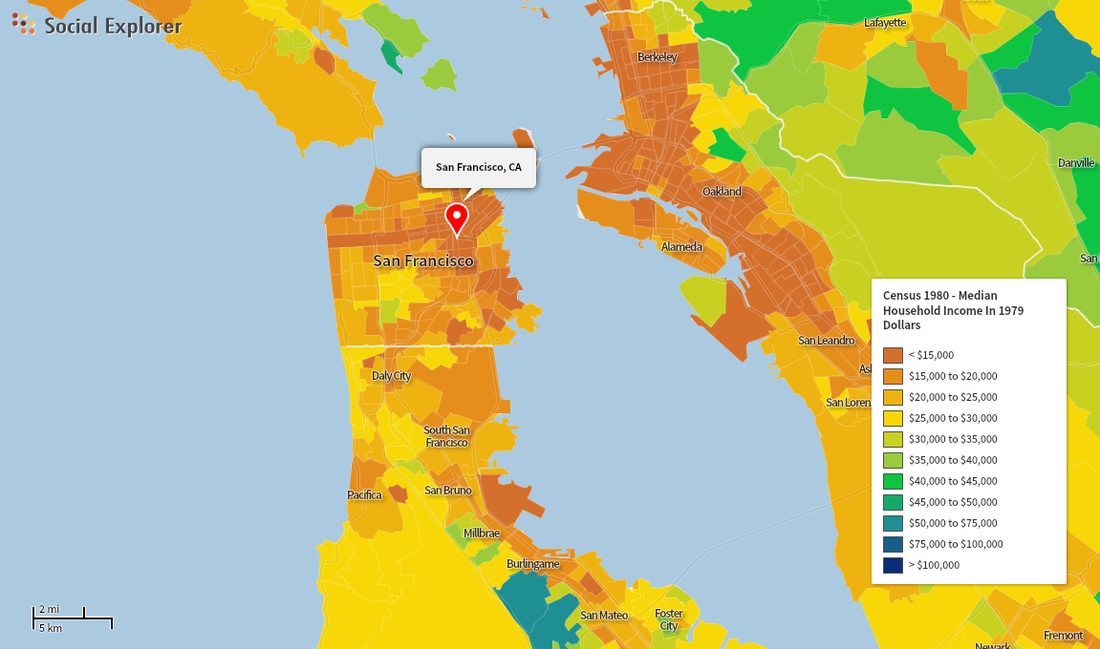
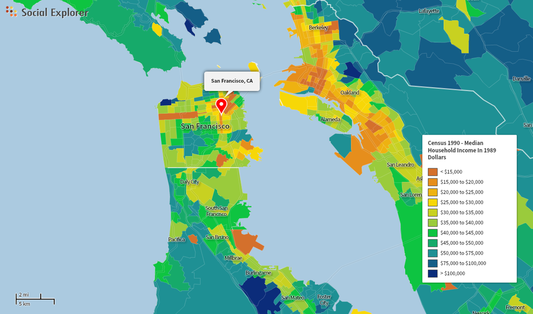
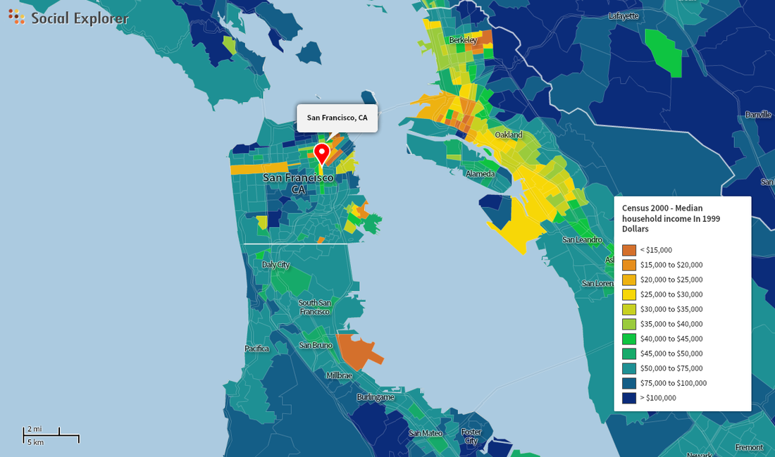
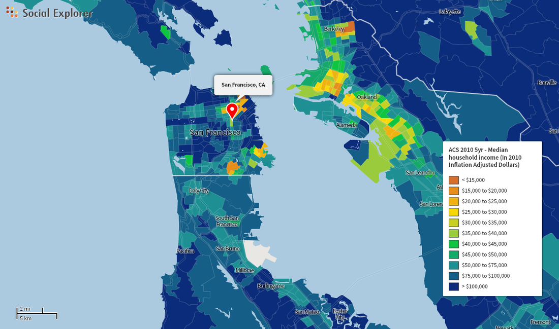
(Source: Socialexplorer.com)
Poverty & Spatial Implications
The past 20 years have brought a spatial inversion of poverty, following the "inverse suburbanization" trend. Instead of being concentrated in the central city, lower-income populations have branched out into inner-ring suburbs as they have been priced out of the city by wealthier San Franciscans looking to be closer to business and culture. Matthew Soursourian at the Federal Reserve Bank of San Francisco discusses how this happened in San Francisco in the research brief: “Suburbanization of Poverty in the Bay Area.” Soursourian found that poverty rates have increased throughout the city, but have done so fastest in suburban areas of San Francisco. He attributes this to several factors: the housing bubble boom and burst, the rising land values in the central city, and the decentralization of work opportunities [13].
While some argue that dispersed poverty is better, a lack of density makes it more difficult to provide services to populations in need [13]. And yet, pockets of extreme poverty still persist in the city core today—also without adequate services or access to transit. The Sunnydale public housing development in Visitacion Valley (in the southeastern corner of San Francisco) is an example of an isolated, struggling group in the city—it is surrounded by crime and poor living conditions, but not by health services or grocery stores. Some trace these pockets back to San Francisco’s Urban Renewal in the 70s, when many African Americans were forced to move from western neighborhoods to already-working-class neighborhoods in the southeast. Although many of these receiving neighborhoods (like Bayview and Hunters Point) were once racially mixed, the influx post-Urban Renewal made them less so—and simultaneously further concentrated the lowest incomes of the city [25].
While some argue that dispersed poverty is better, a lack of density makes it more difficult to provide services to populations in need [13]. And yet, pockets of extreme poverty still persist in the city core today—also without adequate services or access to transit. The Sunnydale public housing development in Visitacion Valley (in the southeastern corner of San Francisco) is an example of an isolated, struggling group in the city—it is surrounded by crime and poor living conditions, but not by health services or grocery stores. Some trace these pockets back to San Francisco’s Urban Renewal in the 70s, when many African Americans were forced to move from western neighborhoods to already-working-class neighborhoods in the southeast. Although many of these receiving neighborhoods (like Bayview and Hunters Point) were once racially mixed, the influx post-Urban Renewal made them less so—and simultaneously further concentrated the lowest incomes of the city [25].
Click through the graphics below to see interactions between poverty and space in San Francisco; scroll over for more details.
